
Travel story 11 min read
MyTravelBuddy Stories
Sri Lanka's Hill Country Is Dry Until Noon
October puts Sri Lanka in the second inter-monsoon, and the forecast says something most itineraries get backwards: the famous hill country around Kandy, Nuwara Eliya and Ella is the wettest band on the island right now…
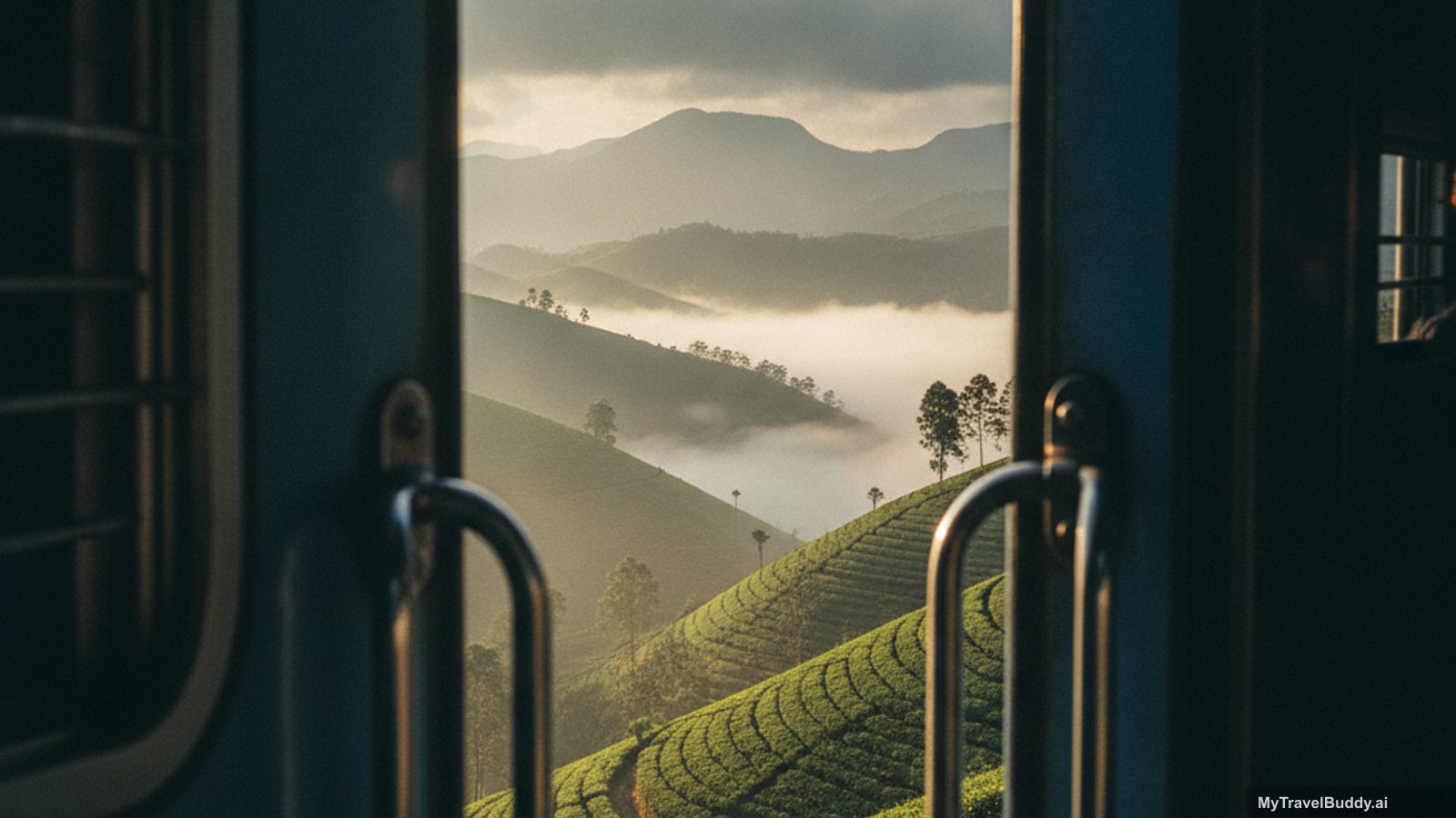
There is a photograph everyone has seen before they ever land in Colombo: a blue train, an open doorway, tea slopes falling away into cloud. It is the reason a lot of people put Sri Lanka's hill country in the middle of their itinerary, and it is a genuinely good reason.
Here is the thing nobody tells you about doing it in October. Right now, that stretch of mountains is the wettest place on the island — wetter than the south coast, wetter than the west, and more than twice as wet as the beaches on the other side. And it still works beautifully, as long as you understand that you are not planning a day here. You are planning a morning.
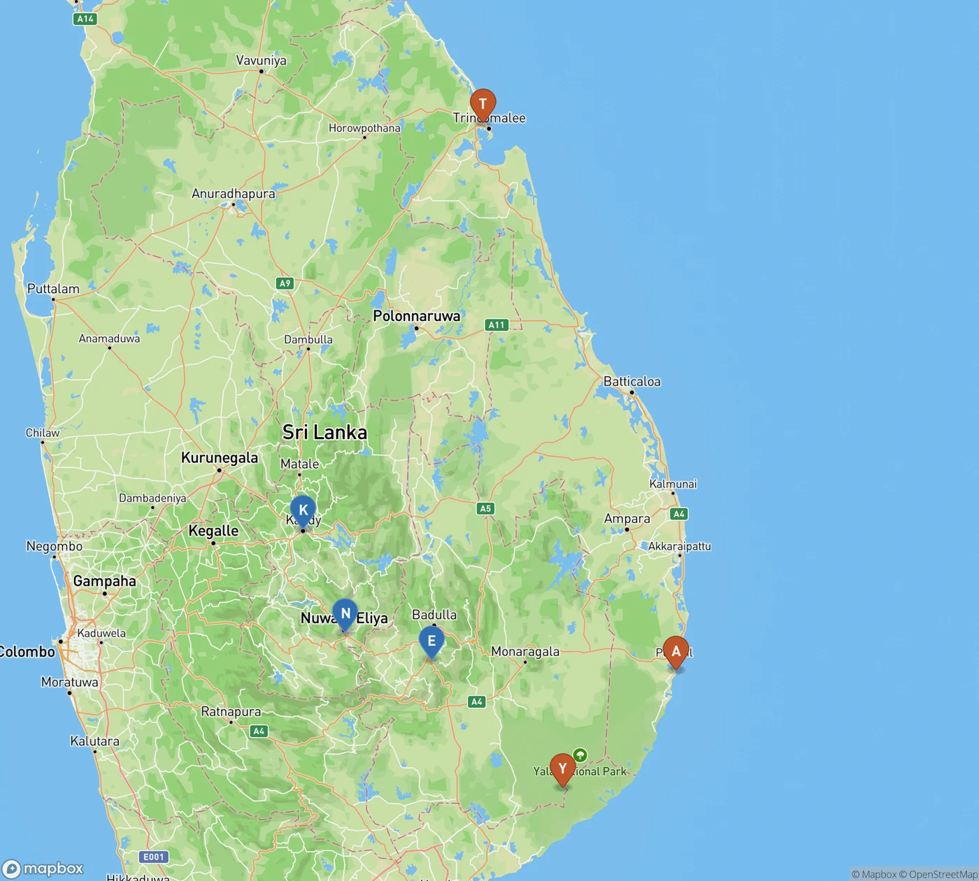
Blue is wet, orange is dry, for 8–23 October. The hill country triangle — Kandy, Nuwara Eliya, Ella — is forecast more than twice the rain of Arugam Bay and Trincomalee.
The rain is not where you think it is
October sits in Sri Lanka's second inter-monsoon, the handover between the southwest monsoon that soaks the west and south from May onward and the northeast monsoon that arrives in November. In between, the weather stops belonging to one coast and goes convective and island-wide — which most guides summarise as "October is a gamble everywhere."
That is not quite true. The gamble is very unevenly distributed. I pulled the sixteen-day forecast for nine points around the island on 7 October, covering 8–23 October:
| Where | Forecast rain, 8–23 Oct | Daytime high |
|---|---|---|
| Ella (hill country) | 303 mm | 24–27 °C |
| Nuwara Eliya | 273 mm | 18–22 °C |
| Kandy | 257 mm | 28–31 °C |
| Galle | 185 mm | 29–30 °C |
| Mirissa | 153 mm | 28–31 °C |
| Colombo | 149 mm | 29–30 °C |
| Yala | 129 mm | 29–31 °C |
| Arugam Bay | 117 mm | 28–32 °C |
| Trincomalee | 115 mm | 29–31 °C |
Read it twice, because it inverts the usual advice. The famous triangle — Kandy, Nuwara Eliya, Ella — is the soggiest band on the map, and the dry corner is the southeast and east, where almost no October itinerary routes you. Ella is forecast roughly two and a half times the rain of Arugam Bay over the same fortnight.
Forecasts this far out are a shape, not a promise, and the numbers will have moved by the time you read this. But the shape is the point, and it matches the long-run pattern: October and November are among the wettest months of the year in Ella and Nuwara Eliya, not the driest.
But look at the clock, not just the map
If the table were the whole story, I would tell you to skip the hills. It isn't, and I won't.
I pulled the hourly forecast for Ella across the same week and sorted it by time of day. Between 05:00 and midday, the whole week adds up to about 4 mm of rain. Between midday and 20:00, the same week produces about 140 mm.
That is not a drizzle that gradually thickens. It is a switch. The hourly means sit near zero all morning — 0.19 mm at 09:00, 0.16 at 10:00, 0.21 at 11:00 — and then at noon the number jumps to 2.70 and keeps climbing through the early afternoon. The mountains heat up, the air lifts, and the sky lets go at roughly the same time every day.
So the hill country in October is not a washout. It is a half-day destination with a very reliable deadline. Everything you came to see — the viewpoints, the bridge, the tea slopes, the walk up to the ridge — happens before lunch. Everything after lunch happens on a veranda with a pot of tea and the sound of water on a tin roof, which, honestly, is its own kind of good.
The train no longer starts where you think
This is the part that will actually change your booking, so let me be plain about it.
Cyclone Ditwah hit in late November 2025 and did the worst damage in Sri Lanka Railways' history — more than 150 landslides and dozens of washouts, concentrated on the hill-country Main Line. The restoration has come in stages, and as of mid-2026 the situation is split:
- Nanu Oya – Ella – Badulla is open again. This is the celebrated half: the climb to Pattipola at 1,891 metres, the highest station on the network, then the escarpment run through Idalgashinna and Haputale with the land falling away to the south, and the final descent into Ella past the Nine Arch Bridge at Demodara.
- The Kandy end is not. The sections around Peradeniya and Nawalapitiya are still under repair, so a direct Kandy-to-Ella train is not currently possible. Full restoration has been targeted for late 2026 into early 2027, but treat that as an aspiration rather than a date.
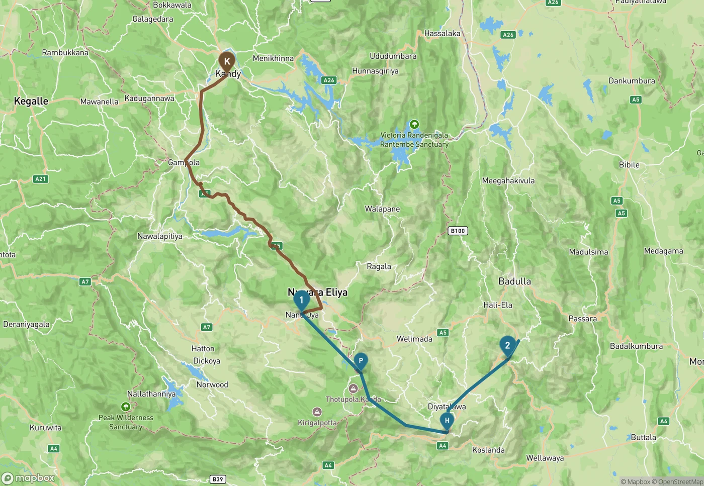
Brown is the road you now drive: Kandy to Nanu Oya, about 79 km and close to two and three quarter hours. Blue is the restored rail section from Nanu Oya (1) over Pattipola (P) and Haputale (H) to Ella (2) — drawn schematically, as the real line curves far more than this.
The workaround is to drive the gap. Kandy to Nanu Oya is about 79 km, and because it is hill road the whole way, it takes closer to two hours and three quarters than the ninety minutes the distance suggests. Then you board at Nanu Oya for the good half.
And here is the accidental gift. The full Kandy–Ella run is roughly 160 km and six to seven hours. Boarding mid-morning in Kandy, as most people used to, you would hit that spectacular escarpment stretch somewhere in the middle of the afternoon — which, per the numbers above, is precisely when the cloud closes in and the view you booked for becomes a grey wall two metres past the doorway. The broken line forces you onto the shorter, higher, better section, and a shorter section is one you can actually fit inside the dry morning window.
Three practical notes. Reserved seats open exactly thirty days ahead on the official portal and the hill-country departures sell out fast, so this is a diary reminder, not a day-of decision. Heading uphill from Nanu Oya, the right-hand side has the better views. And reconfirm before you travel — post-cyclone timetables are still being adjusted, the restored escarpment section is under landslide monitoring, and this is the rainiest fortnight it has seen since reopening. Sri Lanka Railways posts current status, and it is worth a look the night before rather than a surprise at the platform.
An Ella morning that actually fits
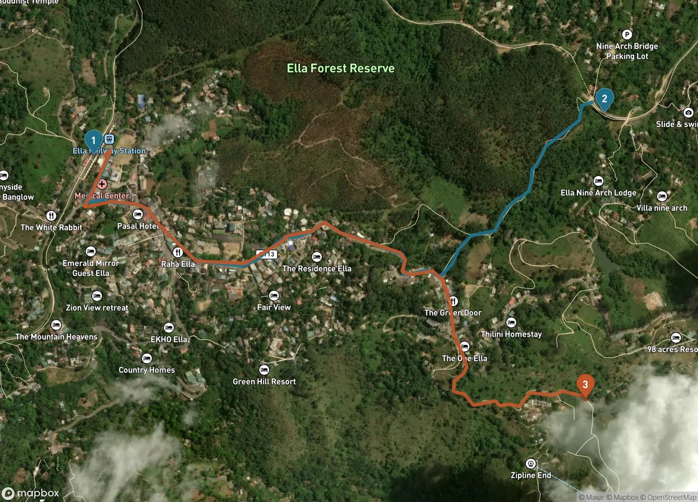
Both of Ella's headline walks start at the station (1): the Nine Arch Bridge (2) is about 2.3 km, roughly 35 minutes on foot, and the Little Adam's Peak trailhead (3) is about 2.4 km in the other direction. Either fits comfortably inside the dry morning window.
Assume you wake in Ella and the sky is doing its usual innocent blue. You have until about noon. That is enough for more than you would think, because the good things here are genuinely close together.
Nine Arch Bridge is a 2.3 km walk from Ella station — about 35 minutes on foot, partly along the track itself, which is as atmospheric as it sounds and requires paying attention to what is coming. Go early. By nine it is busy, and the bridge is the single most photographed object in the country.
Little Adam's Peak is almost the same distance in the other direction, 2.4 km to the trailhead, then a short climb on a well-made path. It is the gentlest big view in the hill country and the one I would choose if you only do one, especially with the valley mist still burning off.
Ella Rock is the serious option: 5 km just to reach the trailhead, then a real climb, and route-finding that defeats plenty of people without a guide. Lovely, but it is a three-to-four hour commitment and it eats the whole window. Choose it instead of the other two, not as well as.
If you would rather drive than walk, Lipton's Seat above Haputale is 25 km and about an hour and a quarter from Ella, through some of the prettiest tea country anywhere — and it is a sunrise place, so it fits the morning rule perfectly. Horton Plains, for World's End, is best reached from the Nanu Oya side, about 31 km and 75 minutes, and the viewpoint is notorious for clouding over by mid-morning even in good weather. In October, be at the gate when it opens or do not bother.
Then let the afternoon go. Ella is full of places built for exactly this — long lunches, slow cafés, the sound of rain on leaves. Pack a light rain layer and shoes you do not mind soaking, and bring something genuinely warm if you are staying in Nuwara Eliya, where nights are forecast at 12–14 °C. People consistently underpack for that; it is a hill station precisely because the British found it cold.
If you would rather be dry: go southeast
If your trip cannot absorb a daily afternoon soaking, the table points somewhere specific, and it is a part of the island most October itineraries skip entirely.
Yala matters right now for a reason beyond weather. Blocks 1 and 2 — the busy, famous sections — have been closed since 14 September for the annual drought closure, and they reopen on 16 October 2026. Blocks 3 to 6 have stayed open throughout. So if you are travelling in the second half of the month, you arrive at a park that has had a month without vehicles in its most visited zone, which is not a bad way to meet it. Ella to Tissamaharama, the usual base, is about 90 km and two hours.
Udawalawe is the dependable alternative — about 124 km and three hours from Ella — and for elephants it is frankly the better park, with none of the leopard-chasing scrum.
Arugam Bay is the driest point in the whole table, and about three hours from Ella. Worth knowing that its surf season is winding down rather than ramping up, and the northeast monsoon will reach this coast within weeks, so go for the quiet and the warm water rather than for a guaranteed swell.
The honest version of all this: a southeast run gives you more usable daylight, and the hill country gives you the mornings and the photograph. Most trips have room for both, in that order — the hills first while you are fresh enough to get up early, then down to the dry corner when you want a day that does not end at lunchtime. If you are still moving the pieces around, it is exactly the kind of sequencing a travel buddy is useful for: the same three places in a different order are a different trip in October.
The short version
Do not cancel the hill country because the rainfall map looks grim. Just stop planning full days there. Set an alarm you would normally resent, take the train from Nanu Oya rather than waiting for the Kandy service that is not running, be at the bridge or on the ridge by eight, and be somewhere with a roof by one. The rain is extremely punctual. You can plan around punctual.
Continue wandering
One more story for the road
October 6, 2026 · Maya Roam
Five Mornings Left at Balloon Fiesta: Take Thursday, Not Saturday
The Albuquerque International Balloon Fiesta has five mornings left this year, and they are not the same event. Wednesday is Flight of the Nations, Thursday and Friday are the Special Shape Rodeo, Saturday is the full M…
Read nextInspired to go?