
Travel story 10 min read
MyTravelBuddy Stories
Istanbul's Bosphorus Is on the Commuter Timetable
The men with laminated boards in Eminönü sell a ninety-minute loop. About two hundred metres away, Şehir Hatları — the municipal operator founded in 1851 — runs roughly thirty-two lines between fifty-three piers, and th…
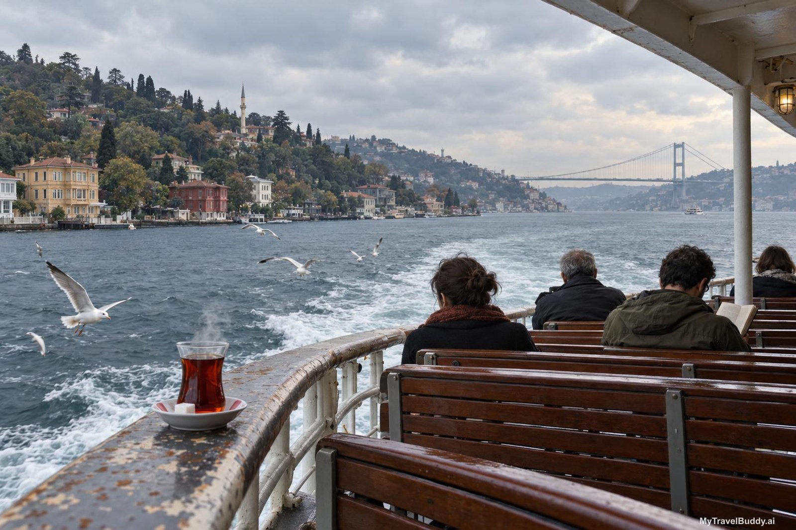
In Eminönü the men with laminated boards find you before you have finished crossing the tram tracks. Bosphorus cruise? Bosphorus cruise, my friend? Ninety minutes, a turn at the second bridge, a recorded voice naming palaces in four languages, and back to the same step you left from. It is not a bad way to spend a morning. It is simply not the best thing happening on that water, and the best thing is tied up about two hundred metres away, at a pier with no laminated board at all.
That pier belongs to Şehir Hatları — City Lines, the municipal ferry operator — and it is where Istanbul goes to work.
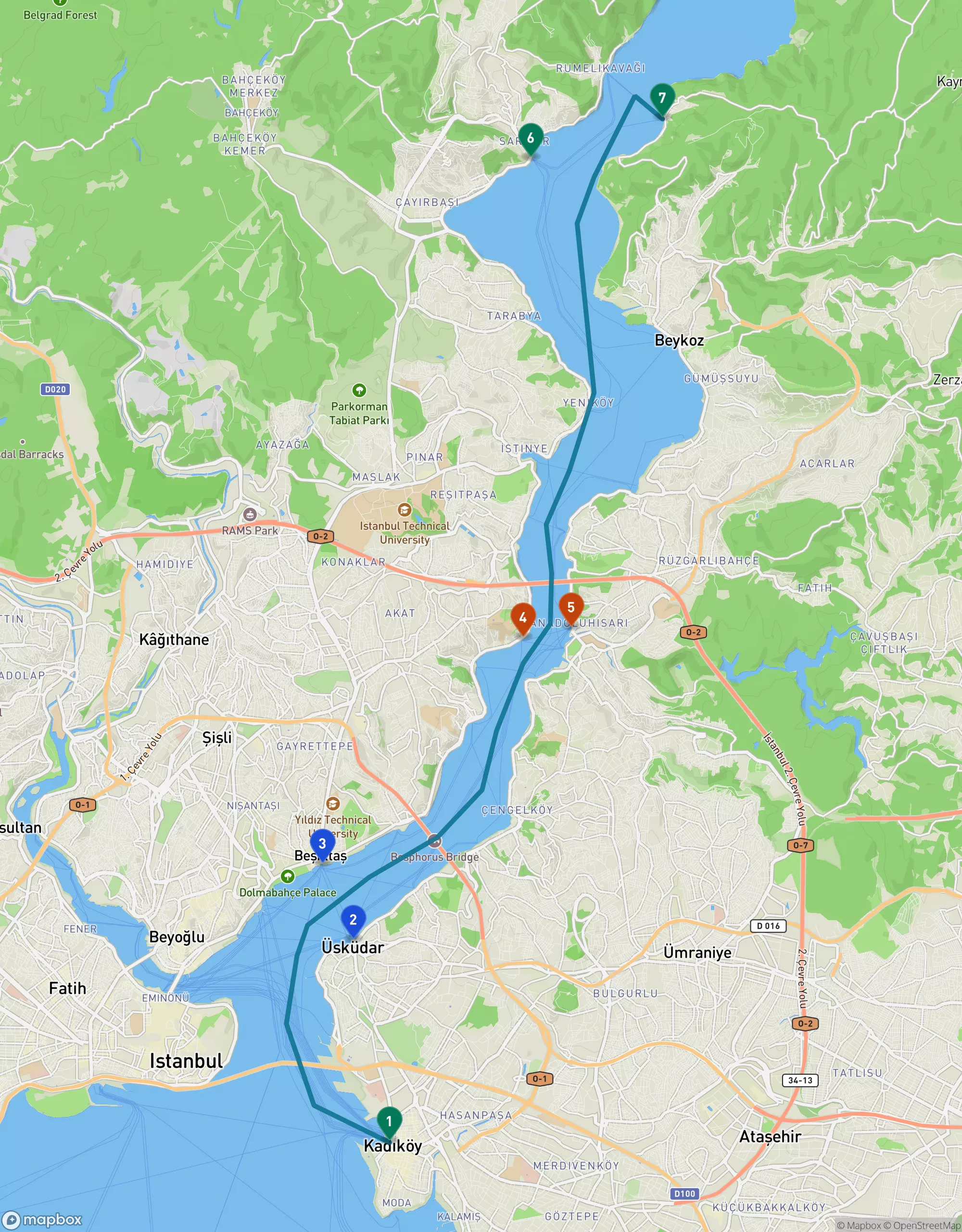
The strait is only 31 kilometres long, and Şehir Hatları works its whole length: Kadıköy (1) and Üsküdar (2) in the south, Beşiktaş (3), the narrows at Aşiyan (4) and Anadolu Hisarı (5), then Sarıyer (6) and Anadolu Kavağı (7) at the top — where the tour boats turn around and go home.
The boat you want is a bus
Şehir Hatları was founded in 1851, under the Ottoman state, as the Şirket-i Hayriye — the Goodwill Company. It has been moving this city across its own water for a hundred and seventy-five years, and it still does it at scale: around thirty passenger vapurs working roughly thirty-two lines between fifty-three piers, carrying some forty million people a year.
Thirty-two lines. The famous Bosphorus tour is one of them.
That is the whole insight, and once you have it the city rearranges itself a little. The tour boat is a product. The other thirty-odd lines are infrastructure — and infrastructure goes to more places, more often, for less money, and will let you off wherever you like. A cruise shows you the shore. A commuter ferry puts you on it.
The Bosphorus is only 31 kilometres long. At its widest it is about 3.4 kilometres across; at its narrowest, between Kandilli Point and Aşiyan, it pinches to roughly 700 metres. It is the narrowest strait in the world used for international navigation, which is why you will find yourself sharing a view with a Panamax bulk carrier riding low toward the Black Sea while a man beside you does the crossword. The whole thing is small enough to ride end to end in a morning, and dense enough that every pier is a different neighbourhood with a different smell.
Three lines nobody will sell you a ticket for
Some of Şehir Hatları's Bosphorus lines are genuinely strange and genuinely wonderful, and no tout in Eminönü has any reason to mention them.
Kadıköy – Sarıyer. This is the long one. It runs the Asian side of the city up to the last proper town before the Black Sea, and it is a commuter service, not a sightseeing service — which means it is scheduled around people getting home, and it costs what a tram ride costs. Kadıköy to Sarıyer is about 19.6 kilometres in a straight line up the water. Google Routes puts the same journey at roughly 28 kilometres and 44 minutes by car in free-flowing traffic, and about 85 minutes on public transport — and Istanbul traffic is not often free-flowing. The ferry is not merely the prettier option. On a bad afternoon it is the sane one.
Anadolu Kavağı – Üsküdar. The tour boats stop at Anadolu Kavağı, eat lunch, and turn around. There is also a plain commuter line running the length of the Asian shore to the same village, about 17 kilometres from Üsküdar as the gull flies. Take it and you arrive at Yoros Castle's hill without a return deadline tied to somebody else's lunch break. Worth knowing: the related Sarıyer – Rumeli Kavağı – Anadolu Kavağı service calls at the tiny Poyraz pier only in the summer season, so do not build an October day around Poyraz.
Aşiyan – Anadolu Hisarı – Küçüksu. This is my favourite thing in the whole network, and it is a triangle about 2.25 kilometres around. It is a ring: Aşiyan on the European shore, across to Anadolu Hisarı, down to Küçüksu, back across. The crossing itself is under a kilometre. And it happens exactly where Mehmet II squeezed the strait shut in 1452, because the two fortresses he used to do it — Rumeli Hisarı on the European bank, Anadoluhisarı on the Asian — stand 910 metres apart, almost precisely on the line this little boat traces several times a day.
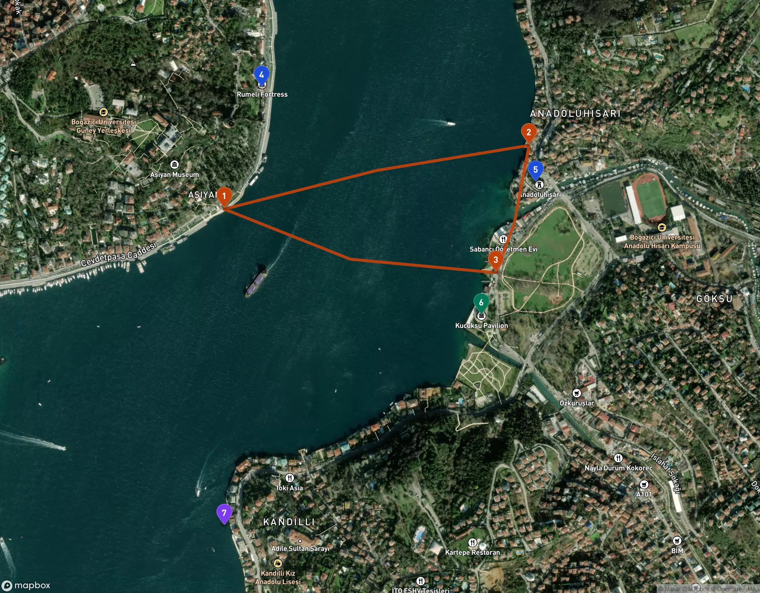
A 2.25-kilometre ring on a public timetable: Aşiyan (1) to Anadolu Hisarı (2) to Küçüksu (3). The crossing runs straight between Rumeli Hisarı (4) and Anadoluhisarı (5) — 910 metres apart — and the strait is at its narrowest, about 700 metres, off Kandilli Point (7).
You can stand at the rail of a working ferry, in the narrowest place in the strait, with a fortress on either side of you, for the price of a bus fare. Nobody advertises this. It is simply how people in Anadolu Hisarı get to the other side.
Step off at Küçüksu and the pavilion is a four-minute walk from the pier — a small, ludicrously ornate 19th-century Ottoman summer lodge on the water, the kind of building that was never meant to be lived in so much as arrived at by boat. Which is, pleasingly, still the correct way to do it.
A day you can actually build
Here is the shape I would give a free day, without pretending the timetable is fixed:
Start on the Asian side at Kadıköy, early, because Kadıköy in the morning is a market, a fish hall and about forty coffee places, and because the ferry piers there are plugged straight into the M4 metro and the T3 tram. Ride north — up the Asian shore if the long line is running, or hop Kadıköy → Beşiktaş and continue from there.
Get off somewhere small in the middle. Kuzguncuk, Çengelköy and Beylerbeyi all have their own piers and all are village-shaped in a way central Istanbul is not. Walk one street back from the water, eat, come back down.
Spend the middle of the day at the narrows. Aşiyan pier, the ring, Anadolu Hisarı, Küçüksu Pavilion, the two fortresses looking at each other across 910 metres of hard current.
Come home in the dark on a different line than you went out on — the Golden Horn service, say, which leaves the Bosphorus entirely and runs Üsküdar – Karaköy – Kasımpaşa – Fener – Balat – Hasköy – Ayvansaray – Sütlüce – Eyüpsultan. A completely different body of water, a completely different set of neighbourhoods, same card.
The piers make this easier than it sounds, because most of them are wired into the rest of the network. Üsküdar connects to Marmaray and the M5. Kadıköy has M4 and T3. Beşiktaş has M7, Sarıyer has M2, Karaköy and Eminönü both sit on the T1 tram. Aşiyan has a funicular up the hill; so do Ortaköy and Beylerbeyi. You are never stranded by a missed boat — you just finish the day on rails instead, which is its own small pleasure.
October, and the wind
Mid-October is a good month for this and a slightly risky one, and both facts come from the same place: the weather stops being settled.
The forecast as I write (14 October) is honest about it. Today and tomorrow are the bad end — thunderstorms and then steady rain across the city, with gusts to around 36–39 km/h and a near-certain chance of precipitation at both Eminönü and Sarıyer. Friday through Sunday eases into scattered showers at 14–17°C, with Saturday still wet at the northern end of the strait. Then it opens: Monday 19th through Wednesday 21st look overcast-to-clear, 18.5–20.7°C, with wind dropping to 8–15 km/h. Thursday brings drizzle and Friday morning may bring fog.
If you have flexibility this month, that Monday-to-Wednesday window is the ferry week.
The reason wind matters more here than temperature is that Istanbul's ferries are genuinely weather-dependent. When the southwesterly lodos gets up, services are curtailed or suspended — the exposed upper-Bosphorus and island runs first. It is not common, it is not dangerous, and it is announced; it simply means that on a gusty day you should treat the far northern piers as a hope rather than a plan, and keep a metro line in your back pocket. Sarıyer runs a degree or two cooler and wetter than Eminönü most days, so pack as if the top of the strait is a slightly different city, because meteorologically it is.
Also: the deck is the entire point, and the deck is cold in a 35 km/h wind. Bring the extra layer you were going to leave at the hotel.
What I would skip
I would skip the 90-minute loop. It costs several times a commuter fare, it turns around before the interesting half of the strait, and its chief product is commentary you can get for free from a guidebook and a window seat.
I am more sympathetic to Şehir Hatları's own Long Bosphorus Tour, which is currently advertised as a single daily sailing from Eminönü around 10:35, running the full strait with roughly three hours ashore at Anadolu Kavağı before coming back. For about six hours of your day it is a real bargain and a lovely thing. But notice what it actually does: it makes the day's shape somebody else's decision, and it puts you ashore in the one village at the one hour that every other passenger is also ashore and hungry. If your day is otherwise unplanned, take it. If you want to get off at Kuzguncuk because the light looked good, don't.
And I would skip Ortaköy at Saturday lunchtime, pier and all. Lovely mosque, impossible crowd. Go on the way back from somewhere else, late.
The practical part
Get an İstanbulkart from a machine at any major pier or metro station and load it with more than you think you need; the machines take cash and cards, and a single card can be tapped for several people. Every boarding is a tap, and transfers within a window are discounted, so a multi-leg ferry day costs less than the sum of its legs. Tour boats are a separate transaction; commuter lines are not.
Do not trust any timetable you read in an article, including this one. Şehir Hatları shifts its schedules seasonally and the winter timetable is thinner than the summer one, particularly on the small Bosphorus lines and the ring. Check the operator's own site or the pier board on the morning you travel, and photograph the return times the moment you step off at a village pier — that habit has saved me more evenings than any other.
Sit outside. The saloon is warm and has windows and is where you will be tempted to go in October, and it is the wrong choice. Çay comes round on the open deck in a tulip glass for small change, the gulls fly at railing height close enough that people feed them simit, and the city turns past you in a way it never does from land.
Going north up the strait, the European shore is on your left and the Asian on your right — so for the yalıs and the fortresses, pick your side before the boat fills.
The whole thing is almost embarrassingly cheap, and that is the part that stays with me. Istanbul's grandest view is not a ticketed attraction. It is a municipal service, running on a timetable, used mostly by people on their way to work, who have long since stopped looking up.
You should look up.
Continue wandering
One more story for the road

October 13, 2026 · Maya Roam
Sunday Decides the Hà Giang Loop
The Hà Giang Loop's two best weekly markets — Mèo Vạc and Đồng Văn — both trade on Sunday morning, twenty-two kilometres apart, and both are over by half past ten. So the real decision is not which market you want; it i…
Read nextInspired to go?